Digital Humanities and Rome: An Approach to New Tools for the Study of Imperial Roman Geography
DOI:
https://doi.org/10.24215/27187470e047Keywords:
Digital Humanities, roman Geography, Voyant Tools, Historical GIS, RecogitoAbstract
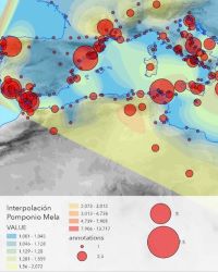
This article aims to characterize the Roman geography of the imperial era through the application of Digital Humanities and Spatial Humanities approaches and techniques. Works of five authors are analyzed: Strabo, Pliny the Elder, Pomponius Mela, Dionysius of Alexandria, and Flavius Arrian. For each one a selection of tools are employed: annotation was performed using Recogito, text analysis was carried out with the aid of Voyant Tools, and finally, spatial analysis was performed in ArcGIS Pro, a tool within which a cartographic reconstruction was also created. All of the above allows us to reinforce and offer a better understanding of Rome’s territoriality. It also adds value to the use of Digital Humanities tools in the study of the History of Ancient Geography.
Downloads
References
Arnaud, P. (2020). Les sources du Stadiasme et la typologie des périples anciens. Geografía y cartografía de la Antigüedad al Renacimiento: estudios en honor de Francesco Prontera (pp. 73-102). Universidad de Sevilla-Universidad de Alcalá de Henares.
Austin, N. J. E. y Rankov, N. B. (2002). Exploratio: Military & political intelligence in the Roman world from the Second Punic War to the battle of Adrianople. Routledge.
Ayers, E. (2010). Turning toward place, space, and time. En D. J. Bodenhamer, J. Corrigan y T. M. Harris (Eds.), The spatial humanities (pp. 1-13). Indiana University Press.
Barker, E., Simon, R. y Isaksen, L. (2012). Pelagios: An information superhighway for the ancient world. [Archivo de Video] https://lecture2go.uni-hamburg.de/l2go/-/get/v/13918
Batty, R. (2000). Mela’s Phoenician Geography. The Journal of Roman Studies, 90, 70-94. https://doi.org/10.2307/300201
Benoist, S. (2011). Penser la limite: De la cité au territoire impérial. En T. Kaizer y O. Hekster (Eds.), Frontiers in the Roman world (pp. 31-48). Brill.
Berry, D. M. (Ed.). (2012). Understanding Digital Humanities. Palgrave Macmillan.
Birley, A. (2019). Adriano. RBA Libros.
Bostock, J. y Riley, H. (1857). The Natural History of Pliny. Taylor and Francis.
Bosworth, A. B. (1972). Arrian’s literary development. The Classical Quarterly, 22(1), 163-185.
Brodersen, K. (2001). The presentation of geographical knowledge for travel and transport in the Roman world: Itineraria non tantum adnotata sed etiam picta. En Travel and Geography in the Roman Empire. Routledge.
Brodersen, K. (2004). Mapping (in) the ancient world. The Journal of Roman Studies, 94, 183-190. https://doi.org/10.2307/4135015
Busa, R. (2004). Foreword: Perspectives on the Digital Humanities. En S. Schriebman, R. Siemens, J. Unsworth (Eds.). A Companion to Digital Humanities. Blackwell. https://companions.digitalhumanities.org/DH/?chapter=content/9781405103213_foreword.html
Buzai, G. D. y Baxendale, C. A. (2015). Análisis socioespacial con sistemas de información geográfica marco conceptual basado en la teoría de la geografía. Ciencias Espaciales, 8(2), 391–408. https://doi.org/10.5377/ce.v8i2.2089
Carreras, C. y De Soto, P. (2013). The Roman transport network: A precedent for the integration of the European mobility. Historical Methods: A Journal of Quantitative and Interdisciplinary History, 46(3), 117-133. https://doi.org/10.1080/01615440.2013.803403
Cruz Andreoti, G. y Prieto, F. M. (2022). Etnicidad, identidad y barbarie en el mundo antiguo. Síntesis.
Dematteis, G. y Governa, F. (2005). Territorio y territorialidad en el desarrollo local. La contribución del modelo SloT. Boletín de la Asociación de Geógrafos Españoles, 39, 31-58.
Dilke, O. A. W. (1984). Geographical perceptions of the north in Pomponius Mela and Ptolemy. Arctic, 37(4), 347-351.
Dilke, O. A. W. (1987). Itineraries and geographical maps in the Early and Late Roman Empires. En J. B. Harley y D. Woodward (Eds.), The History of Cartography (Vol. 1, pp. 234-257). Chicago University Press.
Dunn, S. (2019). A history of place in the Digital Age. Routledge. https://doi.org/10.4324/9781315404462
Falconer, W. (1805). Periplus of the Euxine Sea by Arrian of Nicomedia. Oxford.
Falconer, W. y Hamilton, H. (1854-1857). The Geography of Strabo. John Childs and Son.
Fontán, C., Moure Casas, A. García Del Barrio, I. y Arribas, E. (Eds.). (2001). Plinio el Viejo. Historia natural: Libros II-IV. Gredos.
Fuenzalida, M., Buzai, G. D., Jiménez, A. M. y Loza, A. G. de L. (2015). Geografía, geotecnología y análisis espacial: tendencias, métodos y aplicaciones. Editorial Triangulo.
Garzetti, A. (1974). From Tiberius to the Antonines: A history of the Roman Empire, AD 14-192 (J. R. Foster, Trad.). Methuen.
Gregory, I. N. y Ell, P. S. (2007). Historical GIS: Technologies, methodologies, and scholarship. Cambridge University Press.
Gregory, I. N. y Geddes, A. (2014). Toward spatial humanities: Historical GIS and spatial history. Indiana University Press.
Guzmán Arias, C. (Ed.). (1989). Pomponio Mela. Corografia. Universidad de Murcia.
Harley, J. B. y Woodward, D. (1987). The History of Cartography. Chicago University Press.
Heurgon, J. (1952). La date des gobelets de Vicarello. Revue des Études Anciennes, 54(1), 39-50. https://doi.org/10.3406/rea.1952.3467
Jones, H. L. (Ed.). (1917). Strabo. Geography. Harvard University Press.
Khan, Y. (2002) A commentary on Dionysius of Alexandria's guide to the inhabited world, 174-382. [Tesis de Doctorado, College of London]. https://discovery.ucl.ac.uk/id/eprint/1317688
Leroy, P. (Ed.). (2017). Arrian. L’art tactique: Histoire de la succession d’Alexandre. Les Belles Lettres.
Lightfoot, J. L. (2014). Dionysius Periegetes, description of the known world: With introduction, translation, and commentary. OUP Oxford.
Lintott, A. W. (1993). Imperium Romanum: Politics and administration. Psychology Press.
López Quiroga, J. (2008). Gentes barbarae: los bárbaros, entre el mito y la realidad. Antigüedad y Cristianismo: Revista de Estudios sobre Antigüedad Tardía, 25, 11-234.
Mattingly, D. J. (2014). Imperialism, power, and identity: Experiencing the Roman Empire. Princeton University Press.
Nicolet, C. (1991). Space, geography, and politics in the early Roman Empire. University of Michigan Press.
Sack, R. D. y Baker, A. R. H. (1986). Human territoriality: Its theory and history. Cambridge University Press.
Sáez Geoffroy, A. (2019). Territorialidad romana e iconografía provincial en las emisiones monetales de Adriano. Biblio3W Revista Bibliográfica de Geografía y Ciencias Sociales, 1-25.
Sáez Geoffroy, A. (2020). Diseños y narrativas de una geografía global-local en el Imperio Romano en el siglo II. Revista de Historia (Concepción), 27(2), 359-381.
Sáez Geoffroy, A. (2021). Geografía, política y pensamiento militar en época Antonina: una visión del Imperio Romano en el siglo II. GEIMA Historia Antigua Ediciones.
Salway, B. (2001). Travel, itineraria and tabellaria. En C. Adams y R. Laurence (Eds.), Travel and Geography in the Roman Empire (pp. 22-66). Routledge.
Santos, M. (2000). La naturaleza del espacio: técnica y tiempo, razón y emoción. Ariel.
Scheidel, W. y Meeks, E. (2012). ORBIS: The Stanford geospatial network model of the Roman world. Stanford University Libraries.
Sihler, E. G. (1923). Strabo of Amaseia: His personality and his works. The American Journal of Philology, 44(2), 134-144. https://doi.org/10.2307/289556
Silberman, A. (Ed.). (1995). Arrien. Périple du Pont-Euxin. Belles Lettres.
Soto, P. de (2019). Network analysis to model and analyse Roman transport and mobility. En P. Verhagen, J. Joyce y M. R. Groenhuijzen (Eds.), Finding the limits of the Limes: Modelling demography, economy and transport on the Edge of the Roman Empire (pp. 271-289). Springer International Publishing. https://doi.org/10.1007/978-3-030-04576-0_13
Syme, R. (1969). Pliny the procurator. Harvard Studies in Classical Philology, 73, 201-236. https://doi.org/10.2307/311156
Syme, R. (1982). The career of Arrian. Harvard Studies in Classical Philology, 86, 181-211. https://doi.org/10.2307/311194
Talbert, R. J. A. (Ed.). (2000). Barrington atlas of the Greek and Roman world. Princeton University Press.
White, H. (1992). El contenido de la forma: narrativa, discurso y representación histórica. Paidós.
Downloads
Published
How to Cite
Issue
Section
License
Copyright (c) 2023 Andres Saez Geoffroy

This work is licensed under a Creative Commons Attribution-ShareAlike 4.0 International License.
Los autores que publican en esta revista están de acuerdo con los siguientes términos:
- Los artículos publicados en la revista se encuentran disponibles en acceso abierto.
- Los autores conservan los derechos de autor y garantizan a la revista el derecho de ser la primera publicación del trabajo al igual que licenciarlo bajo una Licencia Creative Commons Atribución-CompartirIgual 4.0 Internacional (CC BY-SA 4.0), que permite copiar y redistribuir el material en cualquier medio o formato y remezclar, transformar y construir a partir del material bajo los siguientes términos: debe dar crédito de manera adecuada, brindar un enlace a la licencia, e indicar si se han realizado cambios.
- Los autores pueden depositar el trabajo en un repositorio de preprints, postprints, establecer por separado acuerdos adicionales para la distribución no exclusiva de la versión de la obra publicada en la revista (por ejemplo, situarlo en un repositorio institucional o publicarlo en un libro), con un reconocimiento de su publicación inicial en esta revista.
- Se alienta a los/as autores/as a realizar el depósito de datos en SEDICI, o en cualquier otro repositorio de datos de investigación (como Zenodo, donde la AAHD ha creado un repositorio temático para HUMANIDADES DIGITALES), de manera previa a realizar el envío de la contribución a la revista. De este modo, al remitir el artículo solo se deberá indicar la URL donde se encuentran los datos de investigación.